India’s weather pattern is witnessing a major transition as the scorching heatwave that dominated large parts of the country during May begins to weaken, while the Southwest Monsoon gradually advances over the surrounding seas. According to the latest India Meteorological Department (IMD) weather bulletin issued on 29 May 2026, several regions are expected to experience thunderstorms, strong winds, heavy rainfall, and a noticeable drop in temperatures over the coming days.
The IMD has indicated that heatwave conditions have already abated from most parts of Northwest India and are likely to disappear from most parts of Central India as well. At the same time, weather systems developing over the Arabian Sea, Bay of Bengal, and neighboring regions are creating favorable conditions for rainfall and thunderstorm activity across multiple states.
For millions of Indians waiting for relief from extreme temperatures, this forecast signals the beginning of a significant weather shift that could influence agriculture, travel, water resources, and daily life across the country.
Heatwave Losing Strength Across North and Central India
For much of May 2026, several states in North and Central India witnessed severe heatwave conditions with temperatures crossing 45°C at multiple locations. The highest temperature recorded was 47.5°C at Banda in Uttar Pradesh, highlighting the intensity of the heat spell.
However, the latest IMD assessment suggests that the worst phase of the heatwave may now be ending.
According to the department, prevailing heatwave conditions have already weakened across most areas of Northwest India. Regions that experienced prolonged periods of extreme heat are now likely to witness a gradual fall in daytime temperatures due to increased cloud cover, thunderstorm activity, and moisture incursion.
Central India is also expected to see a gradual reduction in heatwave intensity. Weather experts attribute this change to evolving atmospheric systems and the approaching influence of the Southwest Monsoon.
The expected temperature drop is particularly significant for states such as Uttar Pradesh, Rajasthan, Madhya Pradesh, Haryana, Punjab, and Delhi, where residents have endured several weeks of oppressive heat.
Southwest Monsoon Continues Its Advance
One of the most important developments highlighted in the IMD report is the continued advance of the Southwest Monsoon.
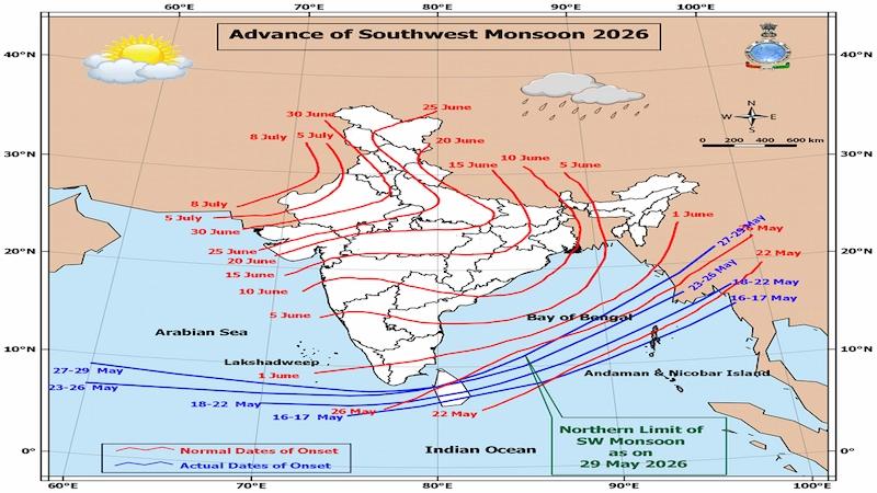
According to the monsoon progress chart released by the IMD, favorable conditions exist for the monsoon to advance further into additional parts of the Arabian Sea, Lakshadweep region, Bay of Bengal, and northeastern sectors over the next two to three days. The current Northern Limit of Monsoon extends through parts of the Indian Ocean, Bay of Bengal, and adjoining regions.
The advancement of the monsoon is a crucial indicator for India’s agriculture sector because nearly half of the country’s cultivated land depends on monsoon rainfall. A timely and well-distributed monsoon can significantly improve crop productivity, groundwater recharge, and reservoir levels.
The IMD’s monsoon map also indicates that the onset progression remains broadly on track, increasing optimism among farmers preparing for the upcoming Kharif sowing season.
Thunderstorm Activity to Intensify Across Several Regions
One of the most striking features of the current weather forecast is the likelihood of moderate to severe thunderstorm activity across large parts of the country.
The IMD has warned that Northwest India, Central India, and East India could experience widespread thunderstorms accompanied by lightning and strong gusty winds between 29 and 31 May.
Some areas may witness squally winds reaching speeds between 70 and 100 kmph, capable of uprooting trees, damaging electric poles, affecting transportation, and disrupting power supply.
States Under Thunderstorm Alert
| Region | Likely Impact |
|---|---|
| Bihar | Severe thunderstorms, hailstorms, heavy rainfall |
| Uttar Pradesh | Strong winds, thunderstorms, dust storms |
| Punjab | Thunderstorms and hail activity |
| Haryana & Delhi | Squally winds and lightning |
| Rajasthan | Dust storms and thunderstorms |
| Madhya Pradesh | Thunderstorms and hailstorms |
| Chhattisgarh | Thunderstorms and gusty winds |
| Jharkhand | Strong winds and rainfall |
| Odisha | Thunderstorms and heavy rain |
The IMD has specifically warned that parts of Bihar may experience thunderstorm winds reaching 80–100 kmph, making it one of the most vulnerable states during this weather event.
Heavy Rainfall Alert for Northeast India
The northeastern states are likely to receive significant rainfall activity during the first week of June.
According to IMD forecasts:
Heavy Rainfall Likely Over:
- Arunachal Pradesh (1–4 June)
- Assam and Meghalaya (2–4 June)
- Nagaland
- Manipur
- Mizoram
- Tripura (31 May–3 June)
The department expects scattered to fairly widespread rainfall across the region, with isolated locations potentially receiving heavy precipitation.
Such rainfall could improve water availability but may also increase the risk of localized flooding and landslides in vulnerable hilly districts.
South India Set for Wet Weather
Several southern states are also expected to receive substantial rainfall during the coming days.
The IMD predicts isolated heavy rainfall over:
| State/Region | Forecast Period |
|---|---|
| Tamil Nadu | 29 May–1 June |
| Kerala | 29 May and 31 May–4 June |
| Lakshadweep | 31 May–4 June |
| Coastal Andhra Pradesh | 29–31 May |
| Rayalaseema | 29–30 May |
| South Interior Karnataka | 29 May |
Thunderstorms accompanied by lightning and gusty winds may also affect Telangana, Karnataka, Andhra Pradesh, and adjoining regions.
For many southern districts that have experienced intense summer heat, these rainfall events could bring considerable relief.
East India Faces Heavy Rain and Strong Winds
The IMD has highlighted East India as another region likely to witness significant weather activity.
Heavy to very heavy rainfall is forecast over:
- Bihar
- Jharkhand
- Odisha
- Andaman and Nicobar Islands
Bihar remains one of the most vulnerable states in the current forecast due to the combined threat of heavy rain, hailstorms, lightning, and damaging winds. The state has already recorded strong gusts exceeding 100 kmph at some locations.
Such conditions can lead to:
- Waterlogging
- Traffic disruptions
- Crop damage
- Power outages
- Reduced visibility
- Localized flooding
Delhi-NCR Weather: Relief from Extreme Heat
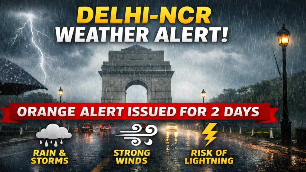
Residents of Delhi-NCR are expected to enjoy a noticeable reduction in temperatures over the next few days.
The IMD predicts:
- Light rainfall
- Thunderstorms
- Lightning activity
- Gusty winds up to 80 kmph
Maximum temperatures are expected to remain around 35–37°C, significantly lower than the intense heat experienced earlier in the month.
Cloudy skies and intermittent rain spells may provide substantial relief from heat stress.
Why Is the Weather Changing So Rapidly?
Meteorologists attribute the changing weather pattern to multiple atmospheric systems currently active over and around India.
The IMD bulletin identifies:
- Upper-air cyclonic circulations
- Western disturbances
- Trough systems
- Moisture influx from the Arabian Sea
- Moisture influx from the Bay of Bengal
These weather systems are interacting simultaneously, creating favorable conditions for cloud formation, rainfall, thunderstorms, and temperature moderation across many parts of the country.
This transition phase is common during the pre-monsoon period when the atmosphere shifts from intense summer heating toward monsoon circulation patterns.
Impact on Agriculture
The forecast carries major implications for Indian farmers.
Positive impacts include:
- Relief from heat stress on crops
- Improved soil moisture
- Better conditions for Kharif sowing
- Groundwater recharge
However, there are also risks:
- Hailstorm damage to orchards
- Waterlogging in low-lying fields
- Crop lodging due to strong winds
- Damage to vegetables and fruit crops
The IMD has advised farmers to:
- Improve drainage systems
- Protect harvested produce
- Use support structures for horticultural crops
- Delay fertilizer application in heavy rainfall zones
- Protect orchards using hail nets where possible.
Fishermen Warning Issued
The IMD has also issued warnings for fishermen.
Fishing activities are discouraged in several areas including:
- Gulf of Mannar
- South Bay of Bengal
- Andaman Sea
- Tamil Nadu coast
- North Gujarat coast
- Parts of the Arabian Sea
Strong winds and rough sea conditions could pose risks to fishing vessels and coastal operations.
Safety Advisory for the Public
The IMD has urged people to remain cautious during thunderstorm activity.
Important Safety Measures:
- Stay indoors during thunderstorms.
- Avoid standing under trees.
- Unplug electrical appliances during lightning.
- Avoid open fields and water bodies.
- Secure loose outdoor objects.
- Follow local weather advisories.
In areas experiencing heavy rainfall, residents should avoid waterlogged roads and remain alert for flash floods and landslides.
Also Read: Cyclone Explained: What It Is, Types, How It Forms & Why It’s So Dangerous
What Does This Mean for India?
The latest IMD report indicates that India is entering a crucial weather transition phase. While heatwave conditions are gradually weakening, rainfall activity is becoming more widespread and the Southwest Monsoon is steadily advancing.
This shift is important not only for weather enthusiasts but also for farmers, businesses, transportation authorities, disaster management agencies, and millions of citizens whose daily lives depend on seasonal weather patterns.
If the monsoon continues progressing as expected, the coming weeks could bring widespread relief from extreme heat while laying the foundation for India’s most important agricultural season.
Source: India Meteorological Department (IMD) Press Release dated 29 May 2026.
For more latest updates on Trending News, Automobile, Education, Technology, Jobs, weather and sports visit IndicDaily.
Frequently Asked Questions (FAQs)
-
Why has the heatwave weakened across parts of India?
According to the IMD, the ongoing heatwave has already abated over most parts of Northwest India and is expected to weaken across Central India as well. Increased cloud cover, thunderstorms, rainfall activity, and the advancing Southwest Monsoon are helping bring temperatures down.
-
Has the Southwest Monsoon advanced further in India?
Yes. The IMD has stated that conditions are favorable for the Southwest Monsoon to advance further into more parts of the Arabian Sea, Lakshadweep region, and Bay of Bengal during the next 2–3 days.
-
Which states are likely to receive heavy rainfall in the coming days?
Heavy rainfall is expected over several states including Arunachal Pradesh, Assam, Meghalaya, Nagaland, Manipur, Mizoram, Tripura, Tamil Nadu, Kerala, Andhra Pradesh, Odisha, Bihar, Jharkhand, Gujarat, and parts of Karnataka. Some locations may also experience very heavy rainfall.